• Welcome to the new COTI server. We've moved the Citizens to a new server. Please let us know in the COTI Website issue forum if you find any problems.
  • We, the systems administration staff, apologize for this unexpected outage of the boards. We have resolved the root cause of the problem and there should be no further disruptions.

Vexing Hexes

Garnfellow

SOC-13
Peer of the Realm
It's been a long time since high school geometry, but I'm not sure about T5's definitions of hexes.

"Hex size (or hex diameter) reflects the distance from the center of a hex to the center of an adjacent similarly sized hex" (37). A World Hex is 1,000 km, a Terrain Hex is 100 km, and a Local Hex is 10 km.

Again and again, Book 3 refers to the distance across a hex as the diameter. For example, "Each Single Hex is 1 km in diameter (from the center of the Single Hex to the center of an adjacent Single Hex)" (41).

So far so good. Book 1 describes a Terrain Hex as "6,500 square km" and a Local Hex as "approximately 65 square km" (41).

But here's a diagram of hexagon

a is the length of the side, R is the circumcircle radius, d is the long diagonal (2 R), r is the apothem, and S is the short diagonal (2 r). The distance from the center of a hex to the center of an adjacent hex is not 2 R, but 2 x apothem (2 r), or S, the short diagonal.

The area of a regular hexagon is 6 x apothem squared / square root of 3. The area of a Local Hex, then, should be 6 x (10/2)^2 / square root of 3, or 87 square km. The area of a Terrain Hex 8,660 (call it 8,700 sq km), and the area of a World Hex 870,000 km.

I believe this only affects the areas in Book 1 and not anything in Book 3. Or have I completely lost it?
 
Last edited:
tl;dr version: the area of a 10 km Local Hex should be 87 sq km, instead of the 65 sq km given in Book 1. This is approximately 8,700 hectares or 21,500 acres. The area of a 100 km Terrain Hex should be 8,700 sq km instead of 6,500 sq km. The area of a 1,000 km World Hex is approximately 870,000 sq km. And the area of a 1 km Single Hex is approximately 1 sq km.
 
Last edited:
It's been a long time since high school geometry, but I'm not sure about T5's definitions of hexes.

"Hex size (or hex diameter) reflects the distance from the center of a hex to the center of an adjacent similarly sized hex" (37). A World Hex is 1,000 km, a Terrain Hex is 100 km, and a Local Hex is 10 km.

Again and again, Book 3 refers to the distance across a hex as the diameter. For example, "Each Single Hex is 1 km in diameter (from the center of the Single Hex to the center of an adjacent Single Hex)" (41).

So far so good. Book 1 describes a Terrain Hex as "6,500 square km" and a Local Hex as "approximately 65 square km" (41).

But here's a diagram of hexagon

a is the length of the side, R is the circumcircle radius, d is the long diagonal (2 R), r is the apothem, and S is the short diagonal (2 r). The distance from the center of a hex to the center of an adjacent hex is not 2 R, but 2 x apothem (2 r), or S, the short diagonal.

The area of a regular hexagon is 6 x apothem squared / square root of 3. The area of a Local Hex, then, should be 6 x (10/2)^2 / square root of 3, or 87 square km. The area of a Terrain Hex 8,660 (call it 8,700 sq km), and the area of a World Hex 870,000 km.

I believe this only affects the areas in Book 1 and not anything in Book 3. Or have I completely lost it?
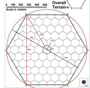
You haven't completely lost it, and T5 swaps the meaning of the size of a hex even within the same diagram. In this, the smaller hexes are supposed to be 100 meters center to center, and they are and that matches the scale on the page. The larger hexes are supposed to be 1km center to center, and they aren't - they are 500 meters outer radius, or 433 meters inner radius, making them 866 meters center to center.

hexagonmeasured.jpeg
 
If it's 10 hexes from center to center, and 100m center to center per hex, why is it not 1km for the larger hexes?
The way it is drawn in the T5 diagram, it's not 10 hexes center to center for the larger hex, it's only 8.6 hexes - using the definition of size of a hex also on the same page, where the hex size is 2x that of the hex inner radius.

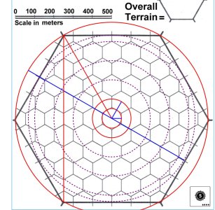
To make it clearer, I've drawn purple dashed circles with radius 200m, 300m, 400m and 433m. The (inner) diameter of a small hex is 100m, thus the larger hex inner diameter is only 8.66 smaller hex inner diameters across.

hexagonmeasuredCircles.jpg
 
If it's 10 hexes from center to center, and 100m center to center per hex, why is it not 1km for the larger hexes?
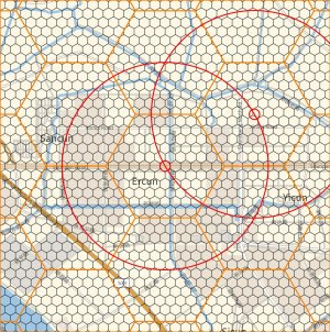
I noticed this when programmatically generating hexes for transcribing real maps to Traveller style maps. The hex counts don't match between the programmatically generated maps and those included in T5, this a 100m/1km hex pattern - I drew circles radius of 50 meters and 1000 meters of adjacent hexes. The center of each hex falls on the 1000 meter radius circle of the other, confirming that these are real 1000m hexes per the definition in T5. Yet the number of smaller hexes making up the larger ones is not the same as in T5. T5 flips the definition of hex size within the same page, the 100 m hexes are inner radius, the 1000 m hexes are outer radius (which makes it not 1000 meters center to center for them)

hexagonmeasuredReal2.jpg
 
Last edited:
Hi,
While I enjoyed reading through this thread, I would say it is academic....and not in the "long time since high school geometry" meaning.

While I can say the US population = N number of people per square mile, that average does not mean anything regarding local density. The population density of the state of New Jersey is much greater than that of the State of Alaska.

Just you have to determine the density of a world, to use its size and determine the local gravity, you need to determine the variations in local population per hexagon before you can correctly assign population to any given hex.

That is, except for those populations which are all in one location.
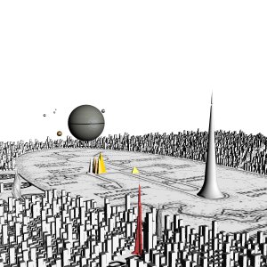
The way I handle this is I have a set of population densities and how they map to the different terrain types. A city has a density of > 10000 people / km^2, a suburb is 3000 - 9999, Rural is 10 to 999, what have you. At the world hex scale almost nothing would be a city hex, the population of the hex would have to be at least 8.6 billion. If you want to show a city that is present though, you then subdivide the hex into subhexes (via the T5 method, but correctly implemented). A 100 km hex would need a population of 86 million within it, and a 10 km hex would need only 866,000. At a close enough resolution, of course, you can differentiate between low density parks within a high density city such as the Imperial Park in the center of Cleon. t5Render.jpeg
 
You haven't completely lost it, and T5 swaps the meaning of the size of a hex even within the same diagram. In this, the smaller hexes are supposed to be 100 meters center to center, and they are and that matches the scale on the page. The larger hexes are supposed to be 1km center to center, and they aren't - they are 500 meters outer radius, or 433 meters inner radius, making them 866 meters center to center.

View attachment 4751
yeah, that circumscribed circle is obviously wrong. They wanted an inscribed circle for center to center distance.
1 across the flats is the distance from center to center, across the corners will be 2/root 3 of that, about 1.155.
the square area is a flats distance times a half flat and a half corner (just use the line labeled 866, and move those triangles to the east end, you'll see). So, if you have 1000 km hexes, then you get 1000 x (500+577.4) ~ 1,077,350 km^2
 
I was going to do a new post, but my proposed title brought up this thread so I'll comment here.

There is a further discrepancy which comes from the orientation of the hexes within the hex. A 1000 km World Hex has the area of one-hundred 100km Terrain Hexes which have the area of one-hundred 10km Local Hexes which have the area of one-hundred 1km Single Hexes...

However, in the world mapping examples, in each case a larger hex has the area of 75 next-smaller hexes. However, if you rotate the larger hex through 30 degrees, with the diameter being from the centre of one hex to the centre of the adjacent hex (passing through the midpoint of the common edge) you do end up with 100 smaller hexes per larger hex (91 full hexes and 18 half-hexes).

Doing that, the areas become:
World Hex - 866025 km^2
Terrain Hex - 8660.25 km^2
Local Hex - 86.6025 km^2 (8660.25 hectares = 21650.25 acres)
Single Hex - 0.866025 km^2

That actually seems rather large for a land grant where the noble has (economic?) control of a terrain hex (roughly the size of North Yorkshire, current population nearly 1.2 million) and outright ownership of a local hex (about 20 times the size of the current Longleat House and park, home of the Marquess of Bath; the total estate is about 4000 hectares).
Perhaps adding to the confusion is that the different scaled hexes are rotated relative to the containing hex (though there is a mistake in this regard in one of the editions of T5 where one of the levels seem to have been forgotten to have been rotated). Terrain hexes are rotated 30º relative to World Hexs, but Local Hexes match the World hexes in orientation.

Trying to make Traveller maps (or most TTRPG maps) coherent and sane is something I've sort of given up on. When I draw a map, I presume Cassini or Gnomonic projections and then retroject that as needed - I just mark the corner points with projection in the appropriate grid coordinates or ECEF and don't try to fit everything into hexes, geographic polygons work just as well these days. That solves the other problem of a land grant being a "hex". Just allocate the appropriate space for it, 1000 acres in an arbitrary shape works just fine.
 
Hi,
While I enjoyed reading through this thread, I would say it is academic....and not in the "long time since high school geometry" meaning.

While I can say the US population = N number of people per square mile, that average does not mean anything regarding local density. The population density of the state of New Jersey is much greater than that of the State of Alaska.
It also ignores that portions of Anchorage are as dense as much of NJ's cities' suburbs ...
Alaska's population lives in under 0.05% (1/2000th) of the land in Alaska. When you're in Anchorage, you're in densities comparable to many of the smaller cities in the Eastern Seaboard... More than half of Alaska is 0 population per square mile.
One of the interesting issues with Anchorage is the geological/geographical issue of being right on top of a very active fault... Almost no high rise housing. Most apartments are in 2 or 3 story buildings, some up to 4, if one of them is a half-basement. There are a number of high rise hotels, and a number of high rise business buildings (ARCO, BP, the McKay building), and tall but not high rise: the city offices building (which used to be a hospital), the new city hall...
Anchorage cannot hit the density of Jersey City nor NYC, because high rise residential property is always a zoning exception... and the courts have blocked a lot of them.
Just you have to determine the density of a world, to use its size and determine the local gravity, you need to determine the variations in local population per hexagon before you can correctly assign population to any given hex.

That is, except for those populations which are all in one location.
And that really should be rare.
 
And that really should be rare.
I would consider....from my own point of view...that populations under code 6 (5 or less) may very well be "one hex only" where the hex is 10 miles or less in diameter
This is an opinion, not a fact, but I grew up in a 20,000 pop town that fit within that area.

Add in lower techs or difficult situations (strange atmo, etc...) and these would compact a settlment
So, one-settlement situations may not be as rare as you guess.
 
Back
Top